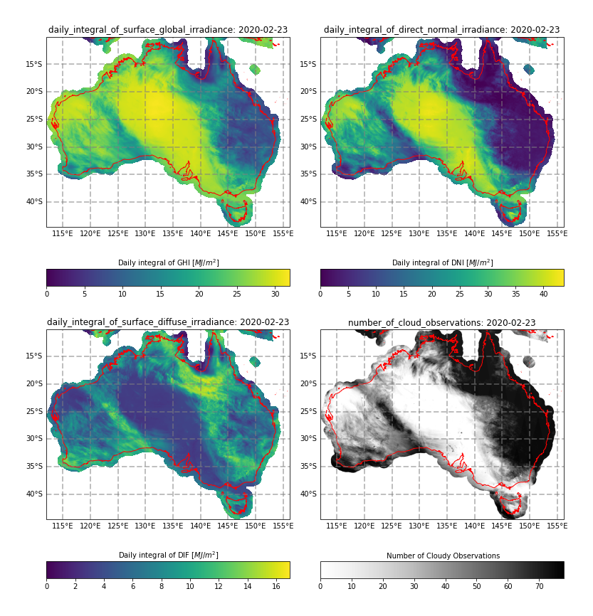
Figure 1. Example solar and cloud parameters for the Australian region for local date 2020-02-23. Clockwise from top left: daily integral of surface global irradiance (commonly referred to as "daily exposure"), daily integral of direct normal irradiance, number of observations during daylight hours classified as cloud, daily integral of surface diffuse irradiance. In clear areas (e.g. central Australia) daily integrals of global and direct irradiance are high, while the diffuse component is low. In cloudy areas (e.g. north east Queensland), the direct component is low, while the diffuse component is relatively high.
Abstract
The Bureau of Meteorology employed the Heliosat-4 radiation model (Qu et al, 2017) as implemented by Mines ParisTech (Gschwind et. al., 2020) to estimate downwelling solar radiation parameters. Heliosat-4 uses estimates of cloud properties derived from satellite observations, estimates of aerosol optical depth, and forecasts of atmospheric ozone and water vapour to estimate instantaneous surface global solar irradiance (known as global horizontal irradiance, GHI) in units of W m-2. Heliosat-4 also produces estimates of the instantaneous intensity of surface direct horizontal irradiance (BHI) in units of W m-2, from which the solar direct beam radiation falling on a surface normal to the beam (known as the direct normal irradiance, DNI, with units W m-2 is calculated.
A bias correction scheme was developed and applied to remove systematic biases in GHI and BHI which can arise from biases and uncertainty in observations, auxiliary products used in the Heliosat-4 forward model, and/or the Heliosat-4 forward model itself. The surface diffuse horizonal irradiance (DIF) is calculated as the difference between GHI and BHI with units of W m-2.
GHI, DNI and DIF are calculated every 10 minutes between sunrise and sunset for each day for the Australian continent, bounded by 112-156.26°E and 10-44.5°S. These 10-minutely observations are integrated with respect to time to produce the daily integral of surface global irradiance (daily_integral_of_surface_global_irradiance, commonly referred to as "daily exposure"), daily integral of direct normal irradiance (daily_integral_of_direct_normal_irradiance) and the daily integral of surface diffuse irradiance (daily_integral_of_surface_diffuse_irradiance). The number of observations during daylight hours (number_of_observations), and the number of these observations classified as cloud (number_of_cloud_observations) are also provided.
A quality mask (quality_mask) is provided within the data sets to identify where there may be data quality issues:
- There are known deficiencies with cloud detections and retrievals over lakes and salt lakes. Daily integral products provide quantities that are interpolated from nearby valid observations.
- A number of nearshore islands have been included by extending the application of the land model to the coastal ocean (up to 100 km from shore). These values are expected to be of lower quality due to cloud mask performance.
Note 1: The daily integral is calculated using the trapezoidal method.
For further detail on the solar irradiance products, please see the Gridded satellite solar observations project: Implementation of Heliosat-4 and the application of bias correction research report.
Format
NetCDF4
Basepath, Filename Template and Data Access
On NCI (requires an NCI account and membership of the rv74 data collection)
Base path: /g/data/rv74/satellite-products/arc/der/himawari-ahi/solar/p1d/<dataset version>/<year-local>/<month-local>/<day-local>
Filename Template: IDE02326.<year-UTC><month-UTC><day-UTC>0000.nc
Note 1: The product is provided for the Australian region. For this region, sunrise and sunset occur in different UTC days. As such, data files and folders are named with the local date. For example, the integral of surface global irradiance with UTC dates ranging from 2020-02-22 18:30 through 2020-02-23 11:30 corresponds to the local-day 2020-02-23. The result of this integral is stored in the IDE02326.202002230000.nc file within the 2020/02/23 directory.
Note 2: The "source" global attribute includes details of the data sets used within the calculations.
On THREDDS (publicly available, no NCI account required)
Bureau of Meteorology - Satellite Derived Products (rv74) THREDDS
Base path: satellite-products/arc/der/himawari-ahi/solar/p1d/<dataset version>/<year-local>/<month-local>/<day-local>
Filename Template: IDE02326.<year-UTC><month-UTC><day-UTC>0000.nc
Note 1: The product is provided for the Australian region. For this region, sunrise and sunset occur in different UTC days. As such, data files and folders are named with the local date. For example, the integral of surface global irradiance with UTC dates ranging from 2020-02-22 18:30 through 2020-02-23 11:30 corresponds to the local-day 2020-02-23. The result of this integral is stored in the IDE02326.202002230000.nc file within the 2020/02/23 directory.
Note 2: The "source" global attribute includes details of the data sets used within the calculations.
Version
Version 1.1: Release of 10-minute solar radiation products for the period 2019-04-01 to present with a latency of 3 months. Version 1.1 uses ABOM ACCESS-G3 Total Column Water Vapour (TCWV) and ACCESS-G3 based Bias Correction. For data prior to 2019-04-01, see Version 1.0.
Version 1.0: Initial release of 10-minute solar radiation products for the period 2015-07-07 through 2019-03-31. Version 1.0 uses NOAA GFS TCWV and GFS-based Bias Correction.
License
Customers intending to use the data for commercial purposes must obtain permission, which is granted through an Access Agreement. For Access Agreement and data enquiries, contact climatedata@bom.gov.au
Update Frequency
Monthly with 3-month data latency.
Temporal extents (YYYY/MM/DD)
2015/07/07 - present (with 3-month data latency)
Spatial Extents
Region bounded by 112-156.26°E and 10-44.5°S
Owner
Bureau of Meteorology
Contact
Satellite Science Team, Research, Bureau of Meteorology
Credit
Solar radiation data derived from satellite imagery processed by the Bureau of Meteorology from the geostationary satellite Himawari-8 operated by the Japan Meteorological Agency using Heliosat-4 software provided by Mines ParisTech. Contains modified Copernicus Atmosphere Monitoring Service Information 2021.
Metadata Example
netcdf IDE02326.202002230000 {
dimensions:
time = 1 ;
latitude = 1726 ;
longitude = 2214 ;
n_possible_obs = 103 ;
variables:
int time(time) ;
time:long_name = "time" ;
time:calendar = "gregorian" ;
time:units = "seconds since 2000-01-01 00:00:00 UTC" ;
time:comment = "Scheduled start time of the first satellite observation in the integral window" ;
float latitude(latitude) ;
latitude:standard_name = "latitude" ;
latitude:long_name = "latitude" ;
latitude:units = "degrees_north" ;
latitude:comment = "latitude at the centre of the pixel" ;
float longitude(longitude) ;
longitude:standard_name = "longitude" ;
longitude:long_name = "longitude" ;
longitude:units = "degrees_east" ;
longitude:comment = "longitude at the centre of the pixel" ;
int crs ;
crs:grid_mapping_name = "latitude_longitude" ;
crs:long_name = "CRS definition" ;
crs:semi_major_axis = 6378137. ;
crs:inverse_flattening = 298.257223563 ;
int input_file_available(n_possible_obs) ;
input_file_available:long_name = "Indicates the presence (0) or absence (1) of input solar products (IDE00326) for each time step within the range time_coverage_start and time_coverage_end in steps of time_step_s. Maintenance periods (0240 and 1440Z) are denoted as 2." ;
input_file_available:time_step_s = 600LL ;
input_file_available:flag_meanings = "absent not_observed_due_to_maintenance" ;
input_file_available:flag_values = 1b, 2b ;
input_file_available:n_present = 101LL ;
input_file_available:n_absent = 1LL ;
input_file_available:n_maintenance = 1LL ;
input_file_available:pc_present = 99. ;
int daily_integral_of_surface_global_irradiance(time, latitude, longitude) ;
daily_integral_of_surface_global_irradiance:_FillValue = -999 ;
daily_integral_of_surface_global_irradiance:long_name = "Daily integral of surface solar irradiance" ;
daily_integral_of_surface_global_irradiance:comment = "The surface called \"surface\" means the lower boundary of the atmosphere. \"shortwave\" means shortwave radiation. Downwelling radiation is radiation from above. It does not mean \"net downward\". Surface downwelling shortwave is the sum of direct and diffuse solar radiation incident on the surface, and is sometimes called \"global radiation\". When thought of as being incident on a surface, a radiative flux is sometimes called \"irradiance\". In addition, it is identical with the quantity measured by a cosine-collector light-meter and sometimes called \"vector irradiance\".\nintegral_of_surface_downwelling_shortwave_flux_in_air_wrt_time is normally expressed in units of W s m-2 but has been converted to MJ m-2 [MJ m-2 == W s m-2 * (1e-6 * 24 * 60 * 60)]" ;
daily_integral_of_surface_global_irradiance:valid_min = 0 ;
daily_integral_of_surface_global_irradiance:valid_max = 4000 ;
daily_integral_of_surface_global_irradiance:units = "MJ m-2" ;
daily_integral_of_surface_global_irradiance:add_offset = 0. ;
daily_integral_of_surface_global_irradiance:scale_factor = 0.01 ;
daily_integral_of_surface_global_irradiance:grid_mapping = "crs" ;
int daily_integral_of_direct_normal_irradiance(time, latitude, longitude) ;
daily_integral_of_direct_normal_irradiance:_FillValue = -999 ;
daily_integral_of_direct_normal_irradiance:long_name = "Daily integral of direct normal solar irradiance" ;
daily_integral_of_direct_normal_irradiance:valid_min = 0 ;
daily_integral_of_direct_normal_irradiance:valid_max = 8000 ;
daily_integral_of_direct_normal_irradiance:units = "MJ m-2" ;
daily_integral_of_direct_normal_irradiance:add_offset = 0. ;
daily_integral_of_direct_normal_irradiance:scale_factor = 0.01 ;
daily_integral_of_direct_normal_irradiance:grid_mapping = "crs" ;
int daily_integral_of_surface_diffuse_irradiance(time, latitude, longitude) ;
daily_integral_of_surface_diffuse_irradiance:_FillValue = -999 ;
daily_integral_of_surface_diffuse_irradiance:long_name = "Daily integral of surface diffuse irradiance" ;
daily_integral_of_surface_diffuse_irradiance:valid_min = 0 ;
daily_integral_of_surface_diffuse_irradiance:valid_max = 4000 ;
daily_integral_of_surface_diffuse_irradiance:units = "MJ m-2" ;
daily_integral_of_surface_diffuse_irradiance:add_offset = 0. ;
daily_integral_of_surface_diffuse_irradiance:scale_factor = 0.01 ;
daily_integral_of_surface_diffuse_irradiance:grid_mapping = "crs" ;
int number_of_observations(time, latitude, longitude) ;
number_of_observations:_FillValue = -999 ;
number_of_observations:long_name = "number of valid observations" ;
number_of_observations:valid_min = 0 ;
number_of_observations:valid_max = 144 ;
number_of_observations:units = "1" ;
number_of_observations:add_offset = 0. ;
number_of_observations:scale_factor = 1. ;
number_of_observations:grid_mapping = "crs" ;
int number_of_cloud_observations(time, latitude, longitude) ;
number_of_cloud_observations:_FillValue = -999 ;
number_of_cloud_observations:long_name = "number of valid observations that were identified as cloud" ;
number_of_cloud_observations:valid_min = 0 ;
number_of_cloud_observations:valid_max = 144 ;
number_of_cloud_observations:units = "1" ;
number_of_cloud_observations:add_offset = 0. ;
number_of_cloud_observations:scale_factor = 1. ;
number_of_cloud_observations:grid_mapping = "crs" ;
int quality_mask(time, latitude, longitude) ;
quality_mask:_FillValue = -999 ;
quality_mask:long_name = "quality mask" ;
quality_mask:flag_meanings = "not_computed no_known_issues_land known_issues_salt_lake known_issues_lake known_issues_nearshore_ocean" ;
quality_mask:flag_values = 0b, 1b, 2b, 3b, 4b ;
quality_mask:grid_mapping = "crs" ;
quality_mask:comment = "There are known issues with some surface types (salt lakes, lakes, nearshore ocean) and some observations (not observed, ocean)" ;
// global attributes:
:Conventions = "CF-1.7" ;
:Metadata_Conventions = "Unidata Dataset Discovery v1.0" ;
:acknowledgment = "The following acknowledgement is required \"Solar radiation data derived from satellite imagery processed by the Bureau of Meteorology from the geostationary satellite Himawari-8 operated by the Japan Meteorological Agency using Heliosat-4 software provided by Mines ParisTech. Contains modified Copernicus Atmosphere Monitoring Service Information 2021.\"" ;
:cdm_data_type = "grid" ;
:comment = "Solar radiation data derived from satellite imagery processed by the Bureau of Meteorology from the geostationary satellite Himawari-8 operated by the Japan Meteorological Agency using Heliosat-4 software provided by Mines ParisTech" ;
:contributor_name = "Mines ParisTech; Commonwealth of Australia, Bureau of Meteorology, Science and Innovation, Research, Weather and Environmental Prediction, Satellite Applications; Commonwealth of Australia, Bureau of Meteorology, Data and Digital, Digital Services, Business Solutions Services" ;
:contributor_role = "Development; Development; Operations" ;
:creator_email = "sat_support@bom.gov.au" ;
:creator_name = "Commonwealth of Australia, Bureau of Meteorology, Data and Digital, Digital Services, Business Solutions Services" ;
:creator_url = "http://www.bom.gov.au/satellite/" ;
:disclaimer = "You are solely responsible for your use of this information and you accept all risks and consequences that might arise from your use of this information.\nThe Bureau of Meteorology (\'Bureau\') is not in any way liable for losses, damages, costs, expenses and liability of any kind that you or any other person may suffer or incur directly or indirectly from you using this information. This information: is subject to the uncertainties of scientific and technical research; may not be accurate, current or complete; is subject to change without notice. Please refer to http://www.bom.gov.au/other/disclaimer.shtml for disclaimer details.\nNeither the European Commission nor ECMWF is responsible for any use that may be made of the information it contains." ;
:geospatial_lat_units = "degree_north" ;
:geospatial_lon_units = "degree_east" ;
:geospatial_vertical_max = 0LL ;
:geospatial_vertical_min = 0LL ;
:geospatial_vertical_positive = "up" ;
:geospatial_vertical_resolution = 0LL ;
:geospatial_vertical_units = "km" ;
:id = "ABOM_HS4_SSI_P1D_GRID_v1.0" ;
:institution = "ABOM" ;
:instrument = "AHI" ;
:keywords = "EARTH SCIENCE" ;
:keywords_vocabulary = "NASA Global Change Master Directory (GCMD) Science Keywords" ;
:license = "Unless provided under a different license by the Bureau of Meteorology, this information in this data file is provided under the CC BY-NC 4.0 International Licence.\nThe CC BY-NC 4.0 International (Creative Commons Attribution Non-Commercial CC BY-NC v.4.0 international) license summary may be found here: [ https://creativecommons.org/licenses/by-nc/4.0/]. The full license text may be found here: [ https://creativecommons.org/licenses/by-nc/4.0/legalcode ].\nFor commercial use, please contact Bureau of Meteorology Climate Data Services at climatedata@bom.gov.au" ;
:naming_authority = "au.gov.bom" ;
:platform = "Himawari-8" ;
:processing_level = "L3" ;
:processing_version = "heliosat-4" ;
:product_specification = "ABOM_HS4_SSI_P1D_GRID_v1.0" ;
:product_suite = "ABOM_HS4_SSI" ;
:product_version = "v1.1" ;
:project = "Solar Radiation Uplift" ;
:publisher_email = "sat_support@bom.gov.au" ;
:publisher_name = "Commonwealth of Australia, Bureau of Meteorology, Data and Digital, Digital Services, Business Solutions Services" ;
:publisher_url = "http://www.bom.gov.au/satellite" ;
:references = "Poulsen C., Majewski L. J. (2022) Gridded satellite solar observations Project: Implementation of Heliosat-4 and application of bias correction, Australian Bureau of Meteorology, Melbourne, Victoria.\n\nQu A., Oumbe A., Blanc P., Espinar B., Gesell G., et al. (2017) Fast radiative transfer parameterisation for assessing the surface solar irradiance: The Heliosat-4 method. Meteorologische Zeitschrift, v26, p33-57. 10.1127/metz/2016/078 . hal-01512589" ;
:standard_name_vocabulary = "CF-1.7" ;
:summary = "Solar radiation data derived from satellite imagery processed by the Bureau of Meteorology from the geostationary satellite Himawari-8 operated by the Japan Meteorological Agency using Heliosat-4 software provided by Mines ParisTech. Contains modified Copernicus Atmosphere Monitoring Service Information 2021." ;
:time_coverage_duration = "P1D" ;
:time_coverage_resolution = "P1D" ;
:title = "Heliosat-4 Solar Radiation - Integrated" ;
:geospatial_lat_max = -9.99 ;
:geospatial_lat_min = -44.51 ;
:geospatial_lon_max = 156.269994506836 ;
:geospatial_lon_min = 111.99 ;
:geospatial_lat_resolution = 0.02 ;
:geospatial_lon_resolution = 0.02 ;
:time_coverage_start = "20200222T183000Z" ;
:time_coverage_end = "20200223T113000Z" ;
:source = "IDE00326.202002221830.nc [uuid: dab23411-522b-45f0-99d7-19a4bee9dbdb]; IDE00326.202002221840.nc [uuid: 4bb7945c-1897-45e0-ac7d-3e01466f03b2]; IDE00326.202002221850.nc [uuid: 309fc155-e179-4d88-884d-a8178573f5f2]; IDE00326.202002221900.nc [uuid: c17e8044-71bf-4e1b-bb1b-c6498f3ee369]; IDE00326.202002221910.nc [uuid: 06b8ec6f-78bc-4ac5-97c9-3d97d9457764]; IDE00326.202002221920.nc [uuid: 9b1725f1-b370-47ba-9683-cc029d784a86]; IDE00326.202002221930.nc [uuid: cce2ff2d-a4f9-4fe5-a7f4-0cf052b855c9]; IDE00326.202002221940.nc [uuid: 74c6e247-71e0-49d9-b165-e67c71e62c4b]; IDE00326.202002221950.nc [uuid: a5f6ea58-77f1-486b-89b5-0fa9f37dbc72]; IDE00326.202002222000.nc [uuid: 602b4cd2-667c-4204-84bd-89f13da42ed9]; IDE00326.202002222010.nc [uuid: 8f8e5984-d445-4764-aafb-8bc67a7f0fd4]; IDE00326.202002222020.nc [uuid: 2f14b922-3723-4e28-9ecf-7787c11f2d2c]; IDE00326.202002222030.nc [uuid: 0aed5b35-def6-4f72-9a82-a5347cf1db52]; IDE00326.202002222040.nc [uuid: a83da705-627a-42b6-aeb0-c859803e7144]; IDE00326.202002222050.nc [uuid: 6a9a0e8a-e057-4963-a653-117766227cc9]; IDE00326.202002222100.nc [uuid: 6567aeb8-91c7-4ea2-b3ad-29a83a978329]; IDE00326.202002222110.nc [uuid: 8745adcb-0530-4bb3-879f-7cc8878ee111]; IDE00326.202002222120.nc [uuid: e1442a2c-42fa-4e54-a153-727ad1853226]; IDE00326.202002222130.nc [uuid: b9527d14-2e8a-4132-9f20-780d5ffcffcd]; IDE00326.202002222140.nc [uuid: 6226931c-0809-4207-9bc9-d21068f1b265]; IDE00326.202002222150.nc [uuid: 623261bf-d0e9-4de3-93e2-cbc8217b5d75]; IDE00326.202002222200.nc [uuid: 981171b7-a83b-48a0-bad1-81e3c8d98710]; IDE00326.202002222210.nc [uuid: eb3dd8d2-11d1-44b7-b015-a0a2aad10d4d]; IDE00326.202002222220.nc [uuid: e91de35b-0265-4b3b-9836-928a3b9199ef]; IDE00326.202002222230.nc [uuid: 75096bca-ea5b-4fbc-a00e-8b32fc847541]; IDE00326.202002222240.nc [uuid: eba5dc00-11a0-46c3-8f17-2652126e03e1]; IDE00326.202002222250.nc [uuid: 6d91d3ed-170b-45cd-9ced-f4a51747f074]; IDE00326.202002222300.nc [uuid: b3401cc7-e7fd-4592-8ce6-a45e162cb0d7]; IDE00326.202002222310.nc [uuid: 6707d268-df12-49a5-93e0-b9fddd2f6cda]; IDE00326.202002222320.nc [uuid: 0a966aab-a96c-4aa9-ba52-e4d9c72f76c1]; IDE00326.202002222330.nc [uuid: b7aeb2f5-5d57-49cf-996b-6c69d8bf0903]; IDE00326.202002222340.nc [uuid: 42e84cf2-53cf-40ba-99ce-0bbf56d71f58]; IDE00326.202002222350.nc [uuid: a1b04f1b-add4-441b-abf6-f17f4e33d03b]; IDE00326.202002230000.nc [uuid: 494572c7-1bcf-4823-880f-49d9f7381cf4]; IDE00326.202002230010.nc [uuid: ddf4b1df-fc36-4c7d-b895-6c01f6d1e52b]; IDE00326.202002230020.nc [uuid: 2e929ae3-e0f2-4419-b658-e95f1fb267c5]; IDE00326.202002230030.nc [uuid: bc88c2a6-8693-430b-98e4-dfdf76c678bf]; IDE00326.202002230040.nc [uuid: 8b57dd11-8967-445d-a864-2cba8995f31d]; IDE00326.202002230050.nc [uuid: 7347da7f-2df3-4785-81ff-dafc5e2a01b1]; IDE00326.202002230100.nc [uuid: 8863509a-3dbb-479b-b940-f027db03a4a5]; IDE00326.202002230110.nc [uuid: 821b6721-f71f-4d80-b59d-ae0246fc9cca]; IDE00326.202002230120.nc [uuid: 51eff178-4ea5-4f85-97bc-6271222dee49]; IDE00326.202002230130.nc [uuid: 8c17d76a-2f93-48c5-8b25-f37e119fd364]; IDE00326.202002230140.nc [uuid: 25530c7b-56e2-4508-aa4d-78d563ebf6f8]; IDE00326.202002230150.nc [uuid: 53512167-5bd4-4f8e-be07-04d8eabc9b38]; IDE00326.202002230200.nc [uuid: 79cc2907-e840-4fce-b217-97e276dbf186]; IDE00326.202002230210.nc [uuid: a36bc774-a271-4167-889a-b4820705e9e4]; IDE00326.202002230220.nc [uuid: eed681fe-5406-422d-8c49-f7ccc504f307]; IDE00326.202002230230.nc [uuid: fe8067b4-16f2-42af-9f33-79bac28e7a09]; IDE00326.202002230250.nc [uuid: f5cb74e7-f9f7-4471-a77c-f2c95ccaab15]; IDE00326.202002230300.nc [uuid: 6c5d7159-1db7-4b38-9a6a-d7e1376224c9]; IDE00326.202002230310.nc [uuid: 12a63903-8867-4243-a56b-e886ab54fdee]; IDE00326.202002230320.nc [uuid: 3341f262-4f25-4f77-8f31-70d3692b2269]; IDE00326.202002230330.nc [uuid: 53b86607-6d4c-41b8-8809-4f7eda3c10b1]; IDE00326.202002230340.nc [uuid: 21e5a186-0639-4750-96c2-6d98c49e15fa]; IDE00326.202002230350.nc [uuid: dd3540cf-b7a1-4358-b378-b3a23ba1f09f]; IDE00326.202002230400.nc [uuid: 7d5bc132-a91c-43f3-9610-0db88d178c35]; IDE00326.202002230410.nc [uuid: 016c021e-c731-4e70-aa6e-dbcff3b34cf5]; IDE00326.202002230420.nc [uuid: 5a55019c-8785-4939-9950-c1aa0de1d96b]; IDE00326.202002230430.nc [uuid: dcd1014b-2e90-4cca-8eeb-33fd13048af7]; IDE00326.202002230440.nc [uuid: 9bff90cb-22c8-4d55-80a7-fdf35d6b61a7]; IDE00326.202002230450.nc [uuid: 15522dbc-93b7-4cf5-91a0-1ed852e2c9e7]; IDE00326.202002230500.nc [uuid: 6647f454-dd4f-48ae-97ef-712e0ae3bb0b]; IDE00326.202002230510.nc [uuid: 25384c54-9361-40e5-ba8c-8d5377cd73b3]; IDE00326.202002230520.nc [uuid: 1964d045-619b-4584-8a67-8e41d0a27426]; IDE00326.202002230530.nc [uuid: 8ff89f9c-7332-47d8-afe0-3b42c842b91b]; IDE00326.202002230540.nc [uuid: 9a4161f6-57fc-4bb4-a903-f87dc88f233c]; IDE00326.202002230550.nc [uuid: c53f909e-224d-4aca-a559-1e2fae040df0]; IDE00326.202002230600.nc [uuid: 5d3227b5-cd03-4352-836c-39384a249de2]; IDE00326.202002230610.nc [uuid: 4208ff29-1580-4d16-b415-c806e6c885f3]; IDE00326.202002230620.nc [uuid: f7cb8b97-84a3-4438-b2a7-2e5fae6c8b3c]; IDE00326.202002230630.nc [uuid: 583983d9-4438-47d2-8bfa-505c2a179368]; IDE00326.202002230640.nc [uuid: 01d80c7b-25ad-4da6-b285-0b6471ca54f3]; IDE00326.202002230650.nc [uuid: c0f5d9fe-33d2-45af-a276-c7e4e1b56892]; IDE00326.202002230700.nc [uuid: b8da11ac-832a-4224-a671-d0dad97b68d1]; IDE00326.202002230710.nc [uuid: c65e982b-8ca1-418f-a56d-efd4000b7853]; IDE00326.202002230720.nc [uuid: 73283a18-0deb-4e64-96b8-819f6ea20e87]; IDE00326.202002230730.nc [uuid: c0ca7dde-a623-473f-a357-d46338d10b5a]; IDE00326.202002230740.nc [uuid: 0489c455-5741-4969-9699-2a8e78f01ad7]; IDE00326.202002230750.nc [uuid: ce71ae9c-cbdd-4710-b40e-b727d71ff949]; IDE00326.202002230800.nc [uuid: db383fba-16f3-4f17-bae1-c42526afc0f1]; IDE00326.202002230810.nc [uuid: cf9047da-865b-4a91-beae-b548a1b86d81]; IDE00326.202002230820.nc [uuid: 57adf721-5c0f-437a-be63-2595f78b589d]; IDE00326.202002230830.nc [uuid: d0892691-7089-4eee-93fb-ca833ad7262b]; IDE00326.202002230840.nc [uuid: ac586ee3-8ecb-44f5-909b-5caa8f20aed2]; IDE00326.202002230850.nc [uuid: 8bc7678e-550a-421b-b2d5-55232bccb4f4]; IDE00326.202002230900.nc [uuid: fdbf0735-1140-417f-9621-dfca7314d8a6]; IDE00326.202002230910.nc [uuid: 4e1c0f3b-ea2a-406d-a4c6-8e2144f57e5d]; IDE00326.202002230920.nc [uuid: 12d064c2-c0b3-4af9-a95b-807771b7d02b]; IDE00326.202002230930.nc [uuid: d0b52aca-1fc5-442a-ad5f-13135f219d5d]; IDE00326.202002230940.nc [uuid: a7fcfd2c-d9ed-4db4-b8db-2f517147edcc]; IDE00326.202002230950.nc [uuid: 8e7401e5-3215-424d-b301-53e089e56741]; IDE00326.202002231000.nc [uuid: ae65f4bc-fbd6-40b1-bb52-b7eeb9b013e8]; IDE00326.202002231010.nc [uuid: 1ed2bf25-6826-44ca-a215-15152152ee44]; IDE00326.202002231020.nc [uuid: 64eb0130-cfb4-4e35-88bc-758570e94705]; IDE00326.202002231030.nc [uuid: 9b17d2e3-da7d-4ad4-8247-a8c64f6d8f2e]; IDE00326.202002231040.nc [uuid: 880b6ba0-81cb-4ebf-9acc-ef243cf6f040]; IDE00326.202002231050.nc [uuid: 75e89e50-2494-4a99-816d-581caa180225]; IDE00326.202002231100.nc [uuid: 6fe251d9-9ae3-43f2-8991-f51e8570c0d4]; IDE00326.202002231110.nc [uuid: 0a776399-d4f1-4957-9f98-f9de19af094b]; IDE00326.202002231120.nc [uuid: 7464e370-5f2e-47b4-a3e1-90ca7445c74d]; IDE00326.202002231130.nc [uuid: 3a7b58d1-fcb7-4d87-b629-59d3b7d1bfa2]" ;
:uuid = "2c023368-8511-41c5-8232-2bd2311c9976" ;
:date_created = "20211223T033511Z" ;
:quality = 0LL ;
:quality_meaning = "0: no_known_issues 1: medium 2: low 4: poor" ;
:history = "heliosat-4; post_process_p1s.py, post_process_p1d.py" ;
}