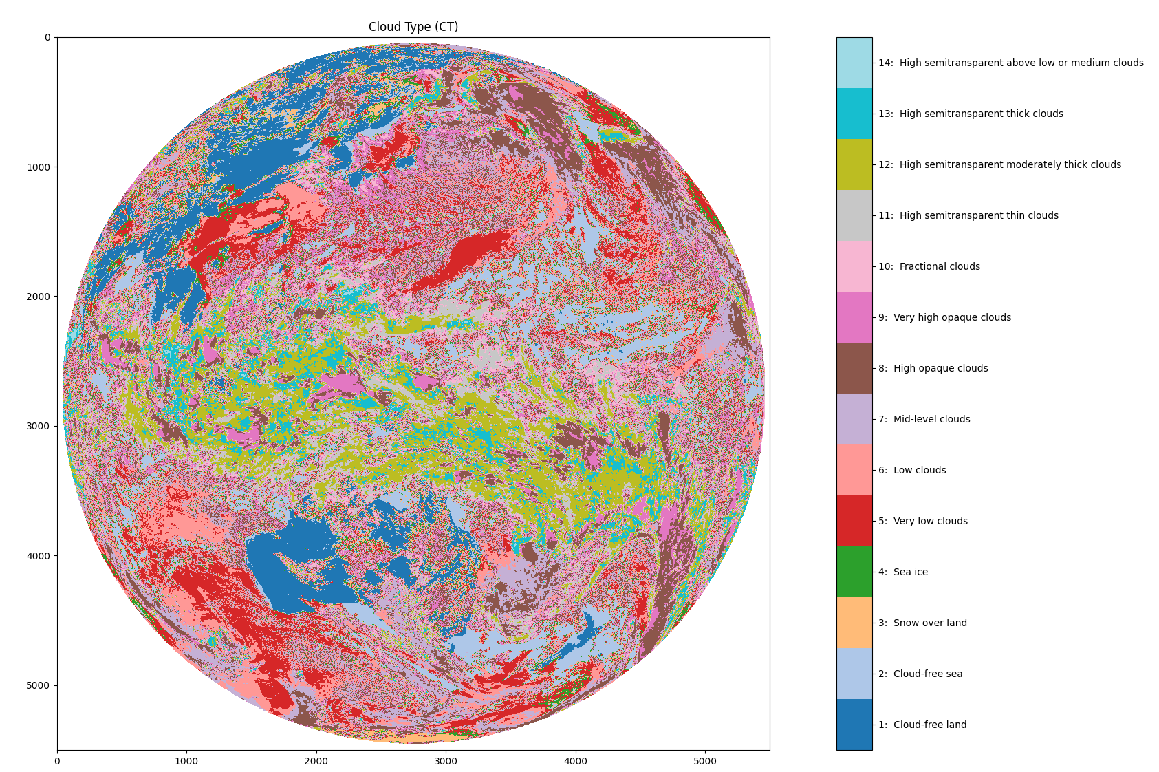
Figure 1. Visualisation of the Cloud Type (CT) product for 2022-01-01 03:00 UTC.
Abstract
The cloud type (CT), developed within the NWC SAF context, mainly aims to support nowcasting
applications. The main objective of this product is to provide a detailed cloud analysis. It may be
used as input to an objective meso-scale analysis.The CT product therefore contains information on the major cloud classes: fractional clouds,
semitransparent clouds, high, medium and low clouds (including fog) for all the pixels identified as
cloudy in a scene.CT is performed by a multi-spectral threshold method: pixels previously detected as cloudy by the Cloud Mask (CMA)
product are classified by a threshold procedure which is applied to the channels combinations that allow the
discrimination of all cloud types. The critical points are the choice of the channels combinations and
the threshold tuning.For further information please view the following documents:
Format
NetCDF4
Basepath, Filename Template and Data Access
On NCI (requires an NCI account and membership of the rv74 data collection)
Base path: /g/data/rv74/satellite-products/arc/der/himawari-ahi/cloud/ct/latest/<year>/<month>/<day>/
Filename Template: S_NWC_CT_<satellite>_HIMA-N-NR_<year><month><day>T<hour><minute>00Z.nc
<satellite>: HIMA08 or HIMA09
On THREDDS (publicly available, no NCI account required)
Bureau of Meteorology - Satellite Derived Products (rv74) THREDDS
Base Path: satellite-products/arc/der/himawari-ahi/cloud/ct/latest/<year>/<month>/<day>/
Filename Template: S_NWC_CT_<satellite>_HIMA-N-NR_<year><month><day>T<hour><minute>00Z.nc
<satellite>: HIMA08 or HIMA09
Version
Version 2.0: Initial release. Processed using EUMETSAT NWCSAF GEO software, version v2021.1. Input data includes Himawari-AHI data, NOAA's GFS 0.5 degree 6 and 12 hour forecasts and Bureau of Meteorology GAMSSA Sea Surface Temperature.
License
Update Frequency
Monthly with 3 month data latency
Temporal extents (YYYY/MM/DD)
2015/07/07 - present (with 3 month data latency)
Spatial Extents
81N ~ 81S, 59E ~ 222E
Owner
Bureau of Meteorology
Contact
Satellite Science Team, Research, Bureau of Meteorology
Credit
Many thanks to the Japan Meteorological Agency (JMA) for providing Himawari-AHI data and NOAA for providing GFS data.
Cloud Type data derived from satellite imagery processed by the Bureau of Meteorology from Himawari-AHI data provided by the Japan Meteorological Agency using software provided by EUMETSAT NWCSAF.
Metadata Example
netcdf S_NWC_CT_HIMA08_HIMA-N-NR_20220101T030000Z {
dimensions:
ny = 5500 ;
nx = 5500 ;
pal02_colors = 256 ;
pal_RGB = 3 ;
pal03_colors = 256 ;
pal01_colors = 256 ;
variables:
ubyte ct(ny, nx) ;
ct:long_name = "NWC GEO CT Cloud Type" ;
ct:valid_range = 1UB, 15UB ;
ct:_FillValue = 255UB ;
ct:ancillary_variables = "ct_status_flag ct_conditions ct_quality ct_pal" ;
ct:coordinates = "lon lat" ;
ct:comment = "1: Cloud-free land; 2: Cloud-free sea; 3: Snow over land; 4: Sea ice; 5: Very low clouds; 6: Low clouds; 7: Mid-level clouds; 8: High opaque clouds; 9: Very high opaque clouds; 10: Fractional clouds; 11: High semitransparent thin clouds; 12: High semitransparent moderately thick clouds; 13: High semitransparent thick clouds; 14: High semitransparent above low or medium clouds; 15: High semitransparent above snow/ice" ;
ct:flag_values = 1UB, 2UB, 3UB, 4UB, 5UB, 6UB, 7UB, 8UB, 9UB, 10UB, 11UB, 12UB, 13UB, 14UB, 15UB ;
ct:flag_meanings = "Cloud-free_land Cloud-free_sea Snow_over_land Sea_ice Very_low_clouds Low_clouds Mid-level_clouds High_opaque_clouds Very_high_opaque_clouds Fractional_clouds High_semitransparent_thin_clouds High_semitransparent_moderately_thick_clouds High_semitransparent_thick_clouds High_semitransparent_above_low_or_medium_clouds High_semitransparent_above_snow_ice" ;
ct:grid_mapping = "geostationary" ;
ushort ct_conditions(ny, nx) ;
ct_conditions:long_name = "Common geophysical and processing conditions" ;
ct_conditions:valid_range = 1US, 65535US ;
ct_conditions:_FillValue = 0US ;
ct_conditions:flag_mask = 1US, 6US, 6US, 6US, 8US, 48US, 48US, 48US, 64US, 128US, 768US, 768US, 768US, 3072US, 3072US, 3072US, 12288US, 12288US, 12288US, 49152US, 49152US, 49152US ;
ct_conditions:flag_values = 1US, 2US, 4US, 6US, 8US, 16US, 32US, 48US, 64US, 128US, 256US, 512US, 768US, 1024US, 2048US, 3072US, 4096US, 8192US, 12288US, 16384US, 32768US, 49152US ;
ct_conditions:flag_meanings = "space night day twilight sunglint land sea coast not_used not_used all_satellite_channels_available useful_satellite_channels_missing mandatory_satellite_channels_missing all_NWP_fields_available useful_NWP_fields_missing mandatory_NWP_fields_missing all_product_data_available useful_product_data_missing mandatory_product_data_missing all_auxiliary_data_available useful_auxiliary_data_missing mandatory_auxiliary_data_missing" ;
ct_conditions:comment = "Common geophysical and processing conditions" ;
ct_conditions:grid_mapping = "geostationary" ;
ubyte ct_cumuliform(ny, nx) ;
ct_cumuliform:long_name = "NWC GEO CT Stratiform/Cumuliform Cloud Detection" ;
ct_cumuliform:valid_range = 1UB, 5UB ;
ct_cumuliform:_FillValue = 255UB ;
ct_cumuliform:ancillary_variables = "ct_status_flag ct_conditions ct_quality ct_cumuliform_pal" ;
ct_cumuliform:coordinates = "lon lat" ;
ct_cumuliform:comment = "1: Stratiform status; 2: Cumuliform status; 3: Mixed status; 4: Cloud-free; 5: Undefined (separability problems)" ;
ct_cumuliform:flag_values = 1UB, 2UB, 3UB, 4UB, 5UB ;
ct_cumuliform:flag_meanings = "Stratiform_status Cumuliform_status Mixed_status Cloud-free Undefined_separability_problems" ;
ct_cumuliform:grid_mapping = "geostationary" ;
ubyte ct_cumuliform_pal(pal02_colors, pal_RGB) ;
ct_cumuliform_pal:long_name = "RGB palette for ct_cumuliform" ;
ct_cumuliform_pal:valid_range = 0UB, 255UB ;
ct_cumuliform_pal:colormodel = "RGB" ;
ct_cumuliform_pal:comment = "Palette applicable to field ct_cumuliform" ;
ubyte ct_multilayer(ny, nx) ;
ct_multilayer:long_name = "NWC GEO CT Multilayer Cloud Detection" ;
ct_multilayer:valid_range = 0UB, 3UB ;
ct_multilayer:_FillValue = 255UB ;
ct_multilayer:ancillary_variables = "ct_status_flag ct_conditions ct_quality ct_multilayer_pal" ;
ct_multilayer:coordinates = "lon lat" ;
ct_multilayer:comment = "0: No multilayer detected; 1: Multilayer detected; 2: Cloud free; 3: Undefined (separability problems)" ;
ct_multilayer:flag_values = 0UB, 1UB, 2UB, 3UB ;
ct_multilayer:flag_meanings = "No_multilayer_detected Multilayer_detected Cloud_free Undefined_separability_problems" ;
ct_multilayer:grid_mapping = "geostationary" ;
ubyte ct_multilayer_pal(pal03_colors, pal_RGB) ;
ct_multilayer_pal:long_name = "RGB palette for ct_multilayer" ;
ct_multilayer_pal:valid_range = 0UB, 255UB ;
ct_multilayer_pal:colormodel = "RGB" ;
ct_multilayer_pal:comment = "Palette applicable to field ct_multilayer" ;
ubyte ct_pal(pal01_colors, pal_RGB) ;
ct_pal:long_name = "RGB palette for ct" ;
ct_pal:valid_range = 0UB, 255UB ;
ct_pal:colormodel = "RGB" ;
ct_pal:comment = "Palette applicable to field ct" ;
ushort ct_quality(ny, nx) ;
ct_quality:long_name = "Common Quality Indicators" ;
ct_quality:valid_range = 1US, 56US ;
ct_quality:_FillValue = 0US ;
ct_quality:flag_mask = 1US, 2US, 4US, 56US, 56US, 56US, 56US ;
ct_quality:flag_values = 1US, 2US, 4US, 8US, 16US, 24US, 32US ;
ct_quality:flag_meanings = "nodata internal_consistency temporal_consistency good questionable bad interpolated" ;
ct_quality:comment = "Common Quality Indicators" ;
ct_quality:grid_mapping = "geostationary" ;
ushort ct_status_flag(ny, nx) ;
ct_status_flag:standard_name = "status_flag" ;
ct_status_flag:long_name = "Information on specific NWC GEO CT processing" ;
ct_status_flag:valid_range = 0US, 63US ;
ct_status_flag:_FillValue = 32768US ;
ct_status_flag:flag_mask = 1US, 2US, 4US, 8US, 16US, 32US ;
ct_status_flag:flag_values = 1US, 2US, 4US, 8US, 16US, 32US ;
ct_status_flag:flag_meanings = "Low_level_thermal_inversion_in_NWP_field Tropopause_temperature_available_from_NWP 138um_used_for_cirrus_identification High_resolution_satellite_data_used No_method_for_stratiform_cumuliform_separation No_method_for_multilayer" ;
ct_status_flag:coordinates = "lon lat" ;
ct_status_flag:grid_mapping = "geostationary" ;
float nx(nx) ;
nx:standard_name = "projection_x_coordinate" ;
nx:long_name = "X Georeferenced Coordinate for each pixel count" ;
nx:units = "m" ;
float ny(ny) ;
ny:standard_name = "projection_y_coordinate" ;
ny:long_name = "Y Georeferenced Coordinate for each pixel count" ;
ny:units = "m" ;
float geostationary ;
geostationary:proj_name = "GEOS141" ;
geostationary:sweep_angle_axis = "y" ;
geostationary:false_northing = 0LL ;
geostationary:grid_mapping_name = "geostationary" ;
geostationary:false_easting = 0LL ;
geostationary:satellite_height = 35785863. ;
geostationary:semi_major_axis = 6378137. ;
geostationary:semi_minor_axis = 6356752.3 ;
geostationary:perspective_point_height = 35785863. ;
geostationary:GeoTransform = -5500000., 2000., 0., 5500000., 0., -2000. ;
geostationary:longitude_of_projection_origin = 140.7 ;
geostationary:proj4 = "+proj=geos +lon_0=140.7 +h=35785863 +x_0=0 +y_0=0 +a=6378137 +b=6356752.3 +units=m +no_defs" ;
geostationary:spatial_ref = "PROJCS[\"unnamed\",GEOGCS[\"unnamed ellipse\",DATUM[\"unknown\",SPHEROID[\"unnamed\",6378137,298.2570248822731]],PRIMEM[\"Greenwich\",0],UNIT[\"degree\",0.0174532925199433]],PROJECTION[\"Geostationary_Satellite\"],PARAMETER[\"central_meridian\",140.7],PARAMETER[\"satellite_height\",35785863],PARAMETER[\"false_easting\",0],PARAMETER[\"false_northing\",0],UNIT[\"Meter\",1]]" ;
// global attributes:
:Conventions = "CF-1.6" ;
:title = "NWC GEO Cloud Type Product" ;
:institution = "Bureau of Meteorology" ;
:source = "NWC/GEO version v2021.1" ;
:comment = "Copyright 2022, EUMETSAT, All Rights Reserved" ;
:references = "http://nwc-saf.eumetsat.int" ;
:contact = "safnwchd@aemet.es" ;
:summary = "Cloud Type Product of the NWC/GEO. Information on the major cloud types and on snow/sea ice occurrence" ;
:keywords = "Cloud Types" ;
:keywords_vocabulary = "GCMD Science Keywords" ;
:id = "S_NWC_CT_HIMA08_HIMA-N-NR_20220101T030000Z.nc" ;
:naming_authority = "Bureau of Meteorology" ;
:cdm_data_type = "Image" ;
:date_created = "2022-12-27T08:53:21Z" ;
:creator_name = "Bureau of Meteorology" ;
:creator_url = "www.bom.gov.au" ;
:creator_email = "SI-Research-SS@bom.gov.au" ;
:project = "NWC/GEO" ;
:processing_level = "Level 2" ;
:time_coverage_start = "2022-01-01T03:00:20Z" ;
:time_coverage_end = "2022-01-01T03:09:40Z" ;
:license = "EUMETSAT user policy" ;
:saf = "NWC/GEO" ;
:product_name = "CT" ;
:product_algorithm_version = "4.1" ;
:satellite_identifier = "HIMA08" ;
:sub-satellite_longitude = 140.7f ;
:centre_projection_longitude = 140.7f ;
:nominal_product_time = "2022-01-01T03:00:00Z" ;
:region_id = "HIMA-N" ;
:region_name = "HIMA-N; CENTRE=0N 140.7E; SIZE=5500x5500pix" ;
:spatial_resolution = 2.f ;
:cgms_projection = "+proj=geos +coff=2750.500000 +cfac=20466275.000000 +loff=2750.500000 +lfac=20466275.000000 +spp=140.699997 +r_eq=6378.137000 +r_pol=6356.752300 +h=42164.000000" ;
:gdal_projection = "+proj=geos +a=6378137.000000 +b=6356752.300000 +lon_0=140.699997 +h=35785863.000000 +sweep=y" ;
:gdal_geotransform_table = -5499996.f, 1999.998f, 0.f, 5499996.f, 0.f, -1999.998f ;
:gdal_xgeo_up_left = -5499996.f ;
:gdal_ygeo_up_left = 5499996.f ;
:gdal_xgeo_low_right = 5499996.f ;
:gdal_ygeo_low_right = -5499996.f ;
:product_quality = 78.90385f ;
:product_completeness = 99.81164f ;
:geospatial_lat_max = 81.04704f ;
:geospatial_lat_min = -81.04704f ;
:geospatial_lon_max = 180.f ;
:geospatial_lon_min = -180.f ;
:product_version = "2.0" ;
:history = "Fri Jan 20 07:30:36 2023: ncatted -O -a product_version,global,c,c,2.0 /scratch/er8/vov548/output/nwcsaf_2021.1_h8_reprocessing/ct//S_NWC_CT_HIMA08_HIMA-N-NR_20220101T030000Z.nc\nFri Jan 20 07:29:45 2023: ncks -O -L 9 --cnk_dmn x,5500 --cnk_dmn y,20 /scratch/er8/vov548/output/nwcsaf_2021.1_h8_compressed/ct/S_NWC_CT_HIMA08_HIMA-N-NR_20220101T030000Z.nc /scratch/er8/vov548/output/nwcsaf_2021.1_h8_reprocessing/ct//S_NWC_CT_HIMA08_HIMA-N-NR_20220101T030000Z.nc\nThu Dec 29 02:02:11 2022: ncatted -O -a product_version,global,c,c,2.0 /scratch/er8/vov548/output/nwcsaf_2021.1_h8//S_NWC_CT_HIMA08_HIMA-N-NR_20220101T030000Z.nc\nThu Dec 29 02:01:20 2022: ncks -O -L 9 --cnk_dmn x,5500 --cnk_dmn y,20 /scratch/er8/vov548/output/nwcsaf_2021.1_h8/S_NWC_CT_HIMA08_HIMA-N-NR_20220101T030000Z.nc /scratch/er8/vov548/output/nwcsaf_2021.1_h8//S_NWC_CT_HIMA08_HIMA-N-NR_20220101T030000Z.nc\n2022-12-27T08:53:21Z (null) Product Created by NWC/GEO v2021.1\n2022-12-27T08:53:21Z (null) GEO-CT.exe 2022-01-01T03:00:00Z /scratch/er8/vov548/ws/nwcsaf_2021.1_h8/install/tmp66z3dl8b/config/safnwc_HIMAN./scratch/er8/vov548/ws/nwcsaf_2021.1_h8/install/tmp66z3dl8b/config/safnwc_CT.cfm4.1 /scratch/er8/vov548/ws/nwcsaf_2021.1_h8/install/tmp66z3dl8b/config/safnwc_CT.cfm4.1" ;
:NCO = "netCDF Operators version 4.7.7 (Homepage = http://nco.sf.net, Code = http://github.com/nco/nco)" ;
}